


A devastating magnitude 8.8 earthquake struck off Russia’s Kamchatka Peninsula early Wednesday morning, triggering tsunami waves that reached Japan, Hawaii, and the United States West Coast, forcing millions to evacuate to higher ground in what scientists are calling the world’s sixth-strongest earthquake ever recorded.
The massive temblor hit at 11:24 PETT (23:24 UTC Tuesday) approximately 136 kilometres east-southeast of Petropavlovsk-Kamchatsky, a city of 180,000 residents on Russia’s remote eastern peninsula. The United States Geological Survey initially reported the quake at magnitude 8.0 before upgrading it to 8.7 and ultimately 8.8, marking it as the most powerful earthquake globally since the catastrophic 2011 Japan disaster.
Tsunami waves of up to 5 metres struck Russia’s Severo-Kurilsk port in the Kuril Islands, washing away structures and forcing the evacuation of 2,000 residents. A state of emergency is in effect in Petropavlovsk-Kamchatsky,” Mayor Yevgeny Belyaev announced via social media, as the region grappled with widespread flooding and infrastructure damage.
Japan Orders 1.9 Million to Evacuate
Japan’s Fire and Disaster Management Agency issued evacuation advisories for nearly 1.9 million residents across 21 prefectures along the Pacific coast, with the largest evacuations occurring in Wakayama prefecture in the southwest, Hokkaido in the north, and Kanagawa, just south of Tokyo.
“It is expected that high tsunami levels will continue for at least one day,” said Yoshimasa Hayashi, the Japanese government’s top spokesperson, after waves reaching 1.3 metres struck Kuji Port in Iwate Prefecture – the highest recorded in Japan.
The Japan Meteorological Agency’s Kiyomoto Masashi warned coastal residents: “Tsunamis can occur for more than a day after the quake.” The agency took the rare step of revising the earthquake’s magnitude from 8.0 to 8.7, then upgrading its tsunami advisory to a warning at 9:40 a.m. local time.
Hawaii Residents Flee as Waters Recede
Dramatic scenes unfolded across Hawaii as residents desperately attempted to reach higher ground whilst waters along the coastline rapidly receded – a telltale sign of an approaching tsunami. Traffic came to a standstill in Honolulu as the evacuation coincided with evening rush hour, with cars jamming streets and motorways even in areas away from the shoreline.
Do not stay near the beaches,” Honolulu Mayor Rick Blangiardi urged residents approximately 3.5 hours before the first waves arrived. “We need people to stay calm, but act accordingly. If you can get to higher ground, if you’re in low-lying areas, please do that.”
Hawaii Governor Josh Green reported that officials observed water receding by 20 to 30 feet at Haleiwa Harbour on Oahu, leaving boats stranded on dry rock and sand. “That gave us pause,” Green said. The state recorded its highest wave at Kahului on Maui, measuring 5.7 feet (1.7 metres) above sea level.
California’s Northern Coast Bears Brunt
The northern California coast experienced the most significant impact on the US mainland, with Crescent City recording a 3.6-foot (1.1-metre) tsunami wave – the highest measured in California. The National Weather Service maintained a tsunami warning for a 40-mile stretch of coastline from south of Klamath to the Oregon border, including the vulnerable Crescent City area.
Continue to avoid beaches and harbours as tsunami activity will persist,” the National Weather Service warned, noting that Crescent City’s underwater geography makes it particularly susceptible to tsunami damage. The city previously suffered devastating tsunamis in 1964 and 2011.
Arena Cove recorded 3-foot waves, whilst other California locations saw smaller but still dangerous surges: 1.6 feet at Point Reyes and 1.4 feet at Monterey. Further north, tsunami waves also reached Washington state and Oregon, though with lesser intensity.
Global Scientific Significance
This is the largest earthquake we’ve had in over a decade worldwide,” Jeffrey Park, Seismologist and Professor of Earth and Planetary Sciences at Yale University, told reporters. “It’s among the top 10 earthquakes that have been measured by humans in the last century and a half.”
The earthquake ties with the 2010 Chile earthquake and the 1906 Ecuador-Colombia earthquake as the joint sixth-strongest ever recorded, according to the US Geological Survey. Only five stronger earthquakes have been documented in modern history, including the devastating 2011 Japan earthquake that killed 19,747 people and triggered the Fukushima nuclear disaster.
Lisa McNeill, Professor of Tectonics at the University of Southampton, explained that the quake “ruptured part of the Kuril-Kamchatka subduction zone,” the same tectonic setting as the 2011 Japan and 2004 Indian Ocean earthquakes. “A subduction zone is where one tectonic plate collides with and slides under another and this generates the largest earthquakes on Earth,” she said.
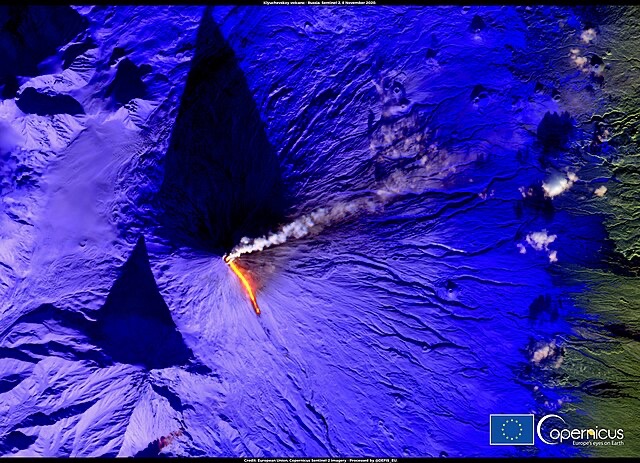
Volcanic Eruption Follows Earthquake
In an extraordinary development, Klyuchevskaya Sopka, Eurasia’s highest volcano at 4,750 metres, erupted following the earthquake. The Kamchatka Volcanic Eruption Response Team reported an ash column rising 3 kilometres above sea level, with the plume drifting 58 kilometres east.
A volcanic eruption, hot lava flowing down the western slope, a powerful glow over the crater and explosions are observed at night,” reported the Russian Union of Travel Industry, noting that tourists in the area chose to stay and witness the natural phenomenon rather than evacuate.
Pacific-Wide Response
The earthquake’s impact reverberated across the Pacific, with tsunami warnings and advisories issued for dozens of nations. Peru’s national emergency centre forecast waves between 1 metre and 2.31 metres to hit its Pacific coastline, whilst Chile declared a red tsunami alert and initiated coastal evacuations.
French Polynesia’s Marquesas Islands, located 10,000 kilometres from the epicenter, experienced water withdrawals – the first sign of incoming tsunamis – at Nuku Hiva, Hiva Oa, and Ua Huka. Authorities initially warned of waves up to 4 metres but later revised estimates to between 1.1 and 2.5 metres.
Indonesia issued warnings for waves of less than 0.5 metres in Papua, North Maluku, and Gorontalo provinces, whilst New Zealand placed a national advisory for all coastal areas warning of “strong and unusual currents” and “unpredictable surges.
Infrastructure Impact and Emergency Response
The earthquake and subsequent tsunamis caused widespread disruption across the affected regions. Japan suspended operations on 41 railway lines and closed three motorways, whilst Sendai Airport shut its runways as a precaution. Workers at the Fukushima nuclear plant, site of the 2011 disaster, were evacuated, though authorities reported no damage to the facility.
Hawaiian and Alaskan Airlines diverted or returned several flights to the US mainland, according to a joint statement, whilst other carriers placed flights on hold pending further information.
Despite the earthquake’s massive power, Russian authorities reported remarkably few casualties. Thank God there were no casualties,” said Kremlin spokesperson Dmitry Peskov, crediting timely tsunami warning systems that enabled successful evacuations. Regional health minister Oleg Melnikov reported that whilst several people sought medical help in Kamchatka, there were “no serious injuries” with all patients “in satisfactory condition.
Scientific Analysis and Future Risks
Matthew Cappucci, a meteorologist tracking the event, described it as the “BIGGEST quake in 14 years” and a “MEGATHRUST quake” where the Pacific plate slides beneath the Okhotsk plate. He noted the earthquake was “very favorable for damaging tsunami” due to the vertical displacement of the sea floor.
Chris Elders, a structural geology expert at Curtin University, explained that the earthquake occurred in the Pacific Ring of Fire, an “area of significant volcanic activity and also earthquake activity.” He added: “The earthquake causes the seabed to lift up a little bit, and that displaces the water sideways, producing the tsunami wave, and it’ll spread away from the epicentre.”
The Kuril-Kamchatka arc experiences frequent earthquakes, with a magnitude 7.4 earthquake on 20 July now recognised as a foreshock to Wednesday’s massive event. The region previously experienced a magnitude 9.0 earthquake in 1952, the fifth-strongest ever recorded, demonstrating the area’s extreme seismic vulnerability.
As Pacific nations begin assessing damage and lifting evacuation orders, scientists warn that aftershocks up to magnitude 7.5 could continue for days or weeks. The event serves as a stark reminder of the Pacific Ring of Fire’s volatile nature and the ongoing threat posed by megathrust earthquakes in subduction zones worldwide.
Follow for more updates on Britannia Daily
Image Credit:
New eruption of the Klyuchevskoy volcano, Russia – Photo by katorisi, licensed under CC BY 2.0, via Wikimedia Commons.