


Met Office warns of ‘incredible’ 10-inch rainfall totals as remnants of Hurricanes Humberto and Imelda barrel towards UK
Britain faces a battering from torrential rain and powerful winds this weekend as the remnants of two Atlantic hurricanes sweep towards the UK, potentially bringing autumn’s first named storm and “pretty incredible” rainfall totals of up to 10 inches.
The Met Office has issued a 37-hour yellow weather warning for western Scotland, running from 5pm Wednesday until 6am Friday, as forecasters warn some villages could become cut off by flooding and residents face potential power cuts.
Parts of the Scottish Highlands could see an extraordinary 250mm of rain – nearly 10 inches – accumulate on the highest ground over the warning period, prompting senior operational meteorologist Marco Petagna to describe the expected totals as “pretty incredible.”
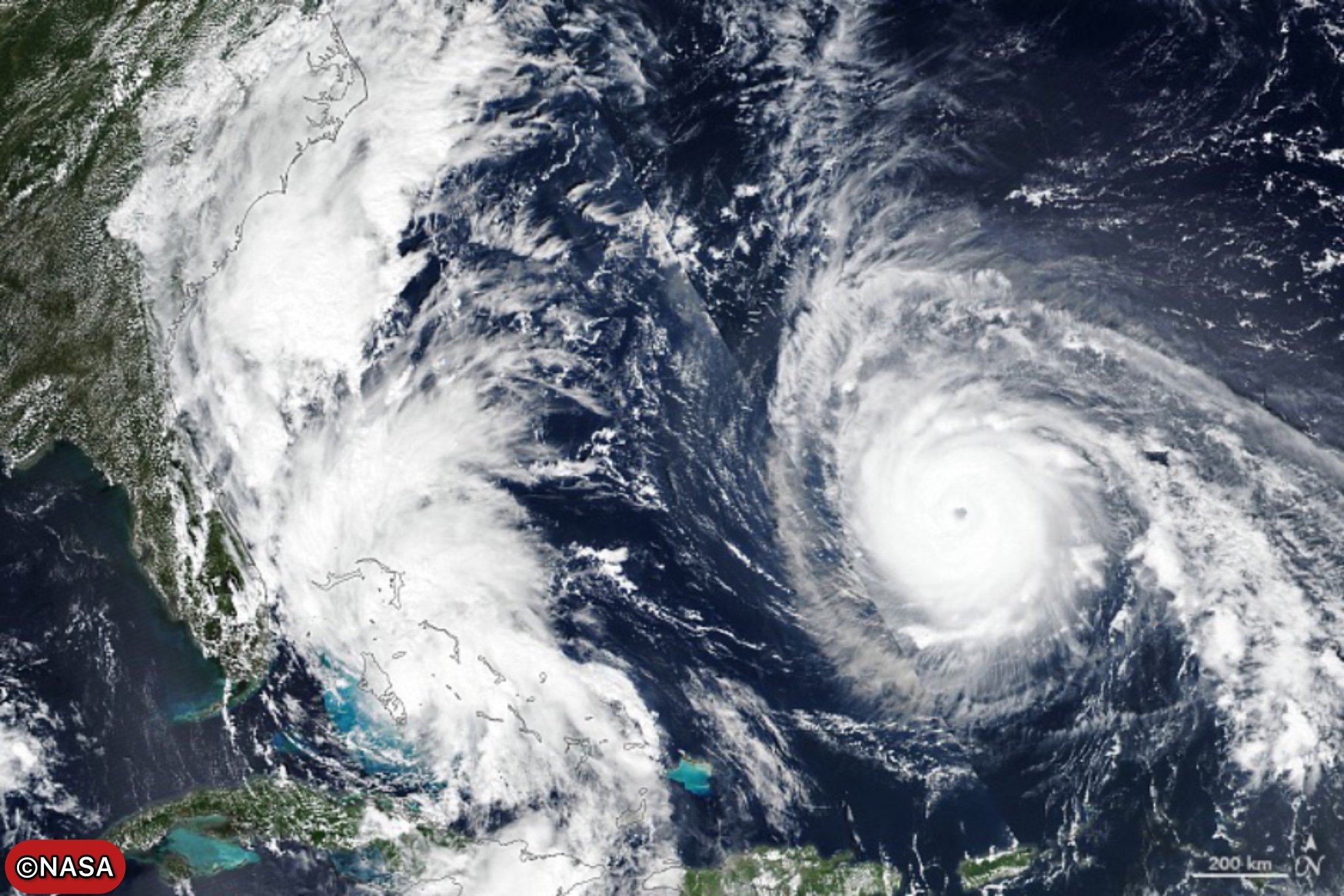
The severe weather threat comes as Hurricane Humberto, currently a Category 3 storm with 115mph winds after peaking at Category 5 strength on Saturday, and Tropical Storm Imelda churn across the Atlantic, with their remnants set to influence UK weather patterns from Friday onwards.
Scotland Bears the Brunt
The yellow rain warning covers large swathes of western Scotland, including parts of Argyll, Ayrshire, Dunbartonshire and Renfrewshire, as well as Central, Tayside & Fife, and the Highlands and Islands. The Met Office warns residents to expect persistent, heavy rain that could lead to transport disruption and flooding.
“Rain is expected to be persistent across western Scotland, lasting from Tuesday through to Thursday night, allowing large rainfall totals to build up,” the Met Office stated. “The heaviest rain will be over hills and mountains, although with pulses of heavier rain extending more widely at times, during Thursday in particular.”
Between 50-75mm of rain is expected widely across affected areas, with 100-150mm possible over west-facing mountains. The most extreme accumulations of 200-250mm are forecast for a few mountain areas from Tuesday through early Friday.
Deputy Chief Meteorologist Chris Bulmer warned: “Rain will be particularly persistent in western Scotland from Wednesday onwards, with the heaviest rain over hills and mountains, though pulses of heavier rain will extend more widely at times, during Thursday in particular.”
Hurricane Double Threat
The weather situation becomes increasingly complex as the week progresses, with the Atlantic hurricanes adding significant uncertainty to forecasts. Hurricane Humberto is currently positioned approximately 265 miles southwest of Bermuda, whilst Tropical Storm Imelda, which has already claimed two lives in Cuba and forced school closures in the Bahamas, sits about 140 miles north of Great Abaco Island.
Imelda, currently packing 65mph winds, is expected to strengthen into a hurricane this morning before being steered out into the open ocean by Humberto’s influence. Both systems could then be caught in the jet stream and pushed towards the UK and northwestern Europe.
Mr Bulmer explained: “The situation becomes more complex later in the week as tropical cyclones Humberto and Imelda, currently over the southwest Atlantic, influence our weather, increasing the risk of a deep low developing near the UK.”
He added: “If this materialises, we could see some very strong winds as well as further heavy rainfall Friday into Saturday, but at this time the development and track of this system remains uncertain. We’re monitoring this closely.”
Fujiwhara Effect Possible
In a rare meteorological phenomenon, the two storms could engage in what’s known as the ‘Fujiwhara effect’ – where two nearby hurricanes spin around each other in a meteorological ‘dance’. Met Office meteorologist Honor Criswick noted: “There is a chance that these two developments could dance around each other for a bit.”
The remnants of Humberto are expected to arrive in the UK on Friday, with the most persistent rain and strongest winds likely through the weekend. This could potentially mark the UK’s first named storm of 2025 – Storm Amy – depending on how the system evolves, though neither weather system has yet met the naming criteria.
North-South Divide
The severe weather will create a marked divide across Britain this week. While Scotland, Northern Ireland and northwest England face the worst conditions, southern and eastern regions will initially enjoy relatively pleasant autumn weather with patchy clouds, sunny spells and temperatures reaching the high teens or low 20s Celsius.
The Met Office described it as a “classic northwest-southeast split” in conditions, with high pressure keeping the southeast settled with light winds and chilly nights, while the northwest faces a series of frontal systems bringing heavy rain and strong winds.
However, this divide is expected to break down from Friday as the hurricane remnants spread wet and windy conditions more widely across the UK, though southern areas may still fare better than northern regions.
Travel Disruption Expected
Authorities are warning of significant travel disruption, particularly in Scotland where the heaviest rain is forecast. The Met Office warning highlights the possibility of:
- Flooding of homes and businesses
- Fast-flowing or deep floodwater causing danger to life
- Delays or cancellations to train and bus services
- Difficult driving conditions and road closures
- Communities becoming cut off by flooded roads
- Power cuts and loss of other services
Marco Petagna’s stark assessment that “ten inches of rain not out of the question over the highest ground” has prompted calls for residents and tourists in affected areas to prepare for severe weather conditions.
Warning Extensions Likely
The Met Office has indicated that the current yellow warning could be extended to cover more areas and potentially upgraded to include wind warnings as confidence in the forecast increases through the week.
“There’s a possibility of further warnings being issued later this week as confidence increases,” the Met Office stated, urging the public to stay updated with the latest forecasts and warnings.
Meteorologist Jim Dale of British Weather Services warned: “There will be a front associated with the remains of Humberto and possibly Imelda that could affect the weather after this week.”
Historical Context
The potential for such extreme rainfall totals is relatively rare in the UK. The forecast of up to 250mm over a few days represents more than a typical month’s rainfall for many areas, even in notoriously wet western Scotland.
The approaching weather systems echo similar events in recent years where Atlantic hurricanes have brought severe weather to Britain after transitioning to extratropical cyclones. While they lose their tropical characteristics, these systems often retain substantial moisture and energy, capable of producing damaging winds and flooding rainfall.
As Britain prepares for what could be autumn’s first named storm, the Met Office continues to monitor the developing situation closely, with further updates expected as the Atlantic hurricanes progress northeastward and their likely impacts become clearer.
Follow for more updates on Britannia DailyRetry