


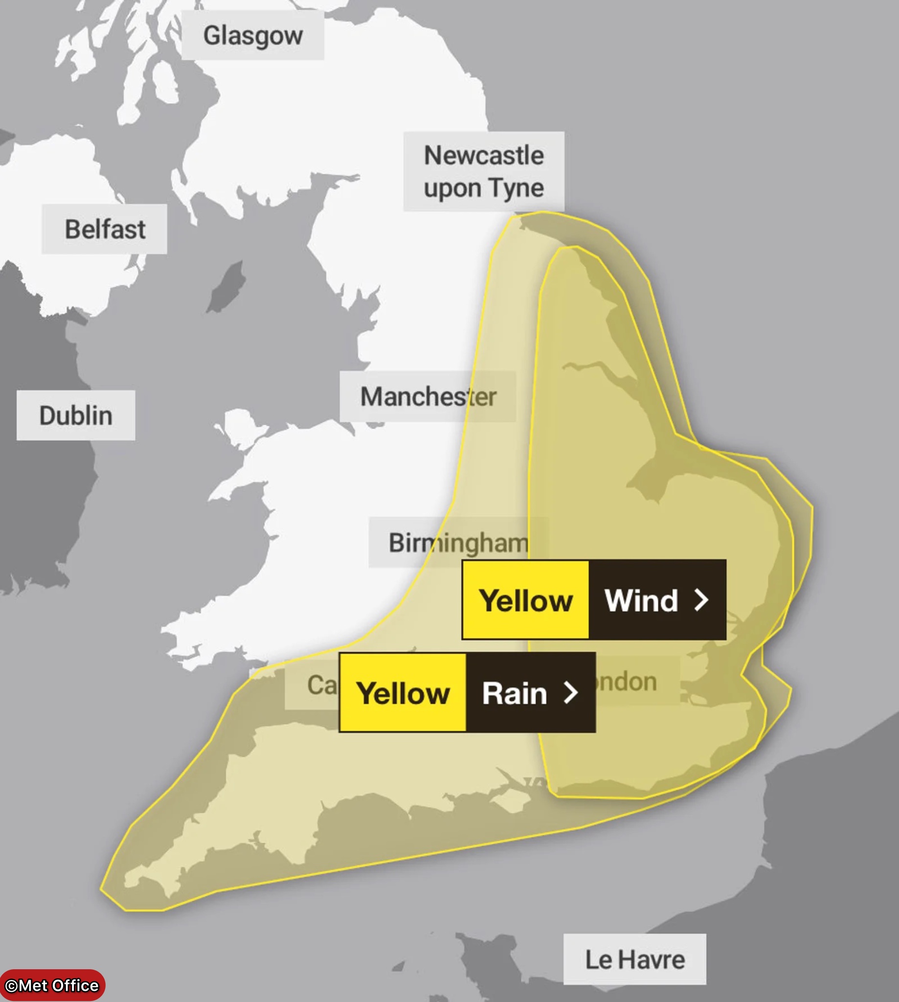
The Met Office has issued yellow weather warnings for strong winds and heavy rain affecting a vast swathe of Britain stretching 371 miles from Land’s End to Hartlepool.
The alerts cover communities across the East Midlands, East of England, London, South East England, North East England, South West England, Wales, parts of the West Midlands and Yorkshire as a complex Atlantic low-pressure system barrels towards the UK.
Forecasters warn the storm could bring travel chaos, power cuts and even flying debris as wind gusts potentially reach 75mph in coastal areas.
Two Separate Warnings Issued
The Met Office has split its alerts between rain and wind, recognising different regions will face peak impacts at different times.
The rain warning kicks in at midnight on Thursday and runs through until 9pm the same evening, with North Devon and Cornwall expected to bear the brunt.
Wind warnings vary by location: eastern England faces strong gusts from 9am Thursday until just before midnight Friday, whilst South West England and Wales will experience the worst winds between 4am Thursday and 6pm.
“Complex Low Pressure” Approaching
Meteorologists are tracking an unusual weather system developing over the mid-Atlantic that will deepen as it approaches British shores.
“A complex low pressure over the mid-Atlantic early this week is expected to move towards the UK whilst deepening, but confidence in the details of its track and intensity as it comes across the UK remains fairly low,” the Met Office explained.
This uncertainty makes the forecast particularly challenging, as small changes in the storm’s path could dramatically alter which areas experience the worst conditions.
Heavy Rain Expected
Despite the uncertainty, forecasters are confident that substantial rainfall will sweep across southwestern Britain on Wednesday evening before spreading rapidly northeast.
“There is at least a medium likelihood that an extensive, and in places heavy swathe of rain will move into southwestern Britain during Wednesday evening and spread quickly northeast,” the Met Office stated.
By early Thursday morning, most affected areas can expect 20-30mm of rainfall, with some locations seeing between 30-50mm.
North Devon and Cornwall face the highest risk of extreme totals, with a “small chance a few places could exceed this” in those regions and more generally across the eastern portions of the warning area.
Winds to Pick Up Thursday
As the rain moves through, conditions will turn increasingly windy with gales initially developing along southern and eastern coasts before spreading more widely across southern Britain during Thursday daytime.
The deepening area of low pressure is expected to cross southeast Britain on Thursday before clearing into the North Sea by Thursday evening.
“Winds will pick up in association with the low, and as it clears from the east coast, very strong northwesterly winds are likely to develop,” forecasters warned.
Gusts Could Reach 75mph
Most areas under the wind warning can expect gusts of 44-55mph, which alone would be sufficient to cause travel disruption and potentially damage structures.
Coastal regions face even fiercer conditions, with 65mph gusts possible near the shoreline.
However, there’s a “smaller chance” that if the low-pressure system deepens more than currently expected, gusts could reach as high as 75mph.
Such extreme winds would most likely occur late morning and into Thursday afternoon, coinciding with rush hour and potentially causing significant disruption.
Journey times will almost certainly be extended as drivers battle wind and rain on major routes across the affected regions.
Give yourself the best chance of avoiding delays by checking road conditions if driving, or bus and train timetables, amending your travel plans if necessary,” the Met Office advised.
Rail services may face speed restrictions or cancellations, particularly on exposed coastal routes where high winds pose safety risks.
Power Cuts Possible
The combination of strong winds and heavy rain increases the likelihood of power outages as trees and debris damage electricity infrastructure.
“People cope better with power cuts when they have prepared for them in advance,” the Met Office noted.
The forecaster recommends gathering essential supplies including torches and batteries, mobile phone power packs and other items that could prove crucial during extended outages.
Flood Risk Warning
With 30-50mm of rain possible in some areas over a relatively short period, flooding becomes a serious concern.
“Check if your property could be at risk of flooding” and take steps to protect it during the winds, the Met Office urged.
Properties in low-lying areas or near rivers and streams face particular risk if drainage systems become overwhelmed by the volume of rainfall.
Coastal Communities on Alert
Those living along Britain’s extensive coastline have been given specific warnings about the dangers posed by stormy seas.
“If you are on the coast, stay safe during stormy weather by being aware of large waves,” the Met Office cautioned.
Large waves generated by strong winds can sweep people off piers, promenades and beaches, with tragic consequences.
Coastal flooding is also possible if high winds coincide with high tides, pushing seawater inland in vulnerable areas.
Flying Debris Danger
Perhaps most concerning, the Met Office has warned about potential injuries and danger to life from flying debris during the strongest gusts.
“There is a small chance of injuries and danger to life from flying debris,” forecasters stated.
Unsecured garden furniture, trampolines, roof tiles and tree branches can all become dangerous projectiles in winds exceeding 60mph.
The warning suggests people should secure or move inside any outdoor items that could become airborne.
Building Damage Possible
Strong winds pose risks to buildings themselves, particularly older structures or those with existing weaknesses.
Roof tiles, chimney pots, scaffolding and building cladding can all be damaged or dislodged by sustained strong winds.
The combination of wind and heavy rain can also cause water ingress through damaged roofs or windows, compounding property damage.
Vast Area Affected
The sheer scale of the warning area – stretching 371 miles from Britain’s southwestern tip to the northeast coast – means millions of people will experience disruption.
Major cities including London, Bristol, Birmingham, Leeds and Newcastle all fall within the warning zones.
The breadth of the affected area reflects the size and power of the approaching low-pressure system.
Uncertainty Remains
Despite issuing yellow warnings, the Met Office has been unusually candid about remaining uncertainties in the forecast.
The complex nature of the developing low-pressure system makes predicting its exact track and intensity challenging even 48 hours in advance.
Small shifts in the storm’s path could mean some areas experience worse conditions than currently expected, whilst others might be spared the worst.
Stay Informed
The Met Office has urged people in affected areas to stay updated as the situation develops and forecasts become more certain.
“When a weather warning is issued”, people should regularly check the forecast for their specific area as conditions could change.
Yellow warnings indicate weather capable of causing disruption but don’t suggest the most severe impacts associated with amber or red alerts.
As Britain braces for this substantial autumn storm, residents across southern and eastern regions should prepare for a thoroughly miserable Thursday with difficult travelling conditions and the possibility of power cuts lasting into Friday.
Follow for more updates on Britannia Daily