


Schools across Northern Ireland have been ordered to shut at noon today as Storm Amy barrels towards Britain with potentially record-breaking winds of up to 95mph, prompting Met Office warnings of flying debris posing a “danger to life”.
The Education Authority confirmed all schools in Counties Antrim, Londonderry, Tyrone and Fermanagh must close by midday, with the decision “taken in the interests of the safety of children, young people and staff” as the first named storm of the 2025/26 season approaches. The amber warning covering western Northern Ireland runs from 3pm to 8pm Friday, warning of damaging winds and potential power cuts.
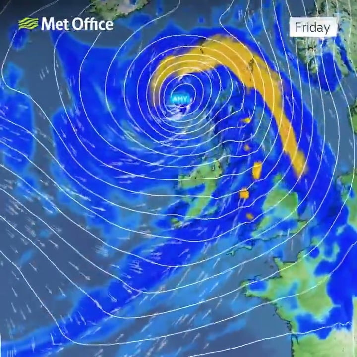
Storm Amy, which formed partly due to the interaction of Hurricanes Humberto and Imelda in the Atlantic, is set to deliver the strongest October winds in years, with the Met Office warning that some weather stations in western Scotland could record new October wind gust records.
Widespread Disruption Expected
The storm’s arrival has triggered an unprecedented cascade of weather warnings across Britain and Ireland. The entire UK falls under either amber or yellow warnings for wind or rain through Saturday night, with the most severe conditions expected across Scotland’s Highlands and Western Isles.
Met Office Chief Forecaster Neil Armstrong warned: “Storm Amy will be an impactful autumn storm for many in Scotland and Northern Ireland, though impacts will also spread to northwest England and Wales. Gusts in excess of 95mph are possible from Friday evening and into Saturday morning.”
The forecaster highlighted particular danger along exposed coastlines, where large waves combined with high winds will create life-threatening conditions. The Scottish Environment Protection Agency (SEPA) urged the public to stay away from coastal areas, with the Firth of Clyde facing the greatest risk of flooding from wave overtopping.
Transport Network Paralysed
ScotRail announced that several railway lines in northern Scotland will close entirely from 6pm Friday, with no replacement transport available. The affected routes include services to Fort William, Inverness, Aberdeen, Wick, Thurso, Kyle of Lochalsh and Perth.
Speed restrictions will be implemented on all other Scottish rail routes from 7pm, with the operator warning that disruption could extend into Sunday whilst Network Rail conducts safety checks for fallen trees and infrastructure damage.
Mark Ilderton, ScotRail service delivery director, said: “Safety is always our top priority. We know how frustrating disruption can be, but these measures are essential to protect our customers and staff.”
Ferry sailings between Cairnryan in Dumfries and Galloway and Larne in County Antrim have been cancelled from midday Friday. The A63 in East Yorkshire is already closed westbound near Hessle due to flooding from heavy rainfall.
Record-Breaking Potential
Storm Amy’s forecast wind speeds are remarkable even by October storm standards. Within the amber warning areas, gusts exceeding 95mph are expected, significantly higher than recent October storms. For comparison, Storm Ashley in October 2024 reached 82mph, whilst Storm Babet in 2023 peaked at 77mph.
The highest October wind gust ever recorded in the UK was 124mph at Rhoose, South Glamorgan, in 1989, whilst Scotland’s October record stands at 106mph recorded at Salsburgh, Lanarkshire, in 1984. Met Office meteorologists suggest Amy could challenge these long-standing records.
Deputy Chief Meteorologist Tom Crabtree said: “Although there is still some uncertainty about the exact track Storm Amy will take, the system will bring gale force winds across northern and western regions, with gusts widely reaching 50 to 60 miles per hour inland in northern Britain.”
Multiple Weather Warnings
The Met Office has issued a complex array of warnings as Storm Amy approaches:
Amber Warnings:
- Northern and western Scotland: 5pm Friday to 9am Saturday (winds up to 95mph)
- Western Northern Ireland: 3pm to 8pm Friday (winds up to 80mph)
Yellow Warnings:
- All Scotland, northern England, north Wales: 3pm Friday to midnight Saturday (wind)
- Western Scotland: 12pm Friday to 3pm Saturday (rain)
- Northwest England including Lake District: 3pm Friday to midnight (rain)
- Northern Ireland: 2pm Friday to noon Saturday (wind)
- Northern Ireland: 11am to 5pm Friday (rain)
Sunday brings an additional yellow warning for strong winds in northeastern Scotland from midnight to 9am.
Rainfall and Flooding Risks
Beyond the devastating winds, Storm Amy threatens significant flooding across western regions. Some exposed hills in western Scotland could see 50 to 80 millimetres of rain, with 30-60mm falling in just 6-9 hours in places.
The British Geological Survey warned of potential landslides in western Scotland. Claire Dashwood, Engineering Geohazards Geologist, said: “BGS records show that landslides have been triggered in western Scotland by similar amounts of rainfall to that being forecast this week. Both natural and infrastructure slopes are likely to be affected.”
SEPA’s Flood Duty Manager David Morgan warned: “A combination of large waves and high winds will bring danger to life on exposed coastlines, particularly around high tides. During this time, we urge the public to stay away from the coast.”
Safety Warnings
Police Scotland urged extreme caution for anyone who must travel during the storm. Chief Superintendent Scott McCarren, head of road policing, said: “I would encourage people to drive to the conditions and be aware of increased stopping distances. In wet weather, stopping distances will be at least double those required for stopping on dry roads.”
The Met Office specifically warned of difficult driving conditions for high-sided vehicles on exposed routes, with particular risk from crosswinds. Emergency services highlighted multiple dangers including:
- Flying debris causing injuries or danger to life
- Damage to buildings, with tiles blown from roofs
- Power cuts affecting homes and mobile phone coverage
- Large waves throwing beach material onto coastal roads
- Fallen trees blocking roads and railways
Political Response
Scotland’s Transport Secretary Fiona Hyslop urged residents to check conditions before any travel: “Motorists will face difficult driving conditions, so it’s vital people plan ahead if they have to travel to see if their route is impacted by the weather. Travellers should check the latest information before they set off, drive to the conditions and follow Police Scotland travel advice.”
Northern Ireland’s Education Authority consulted with the Met Office overnight before making the unprecedented decision to close schools across four counties, affecting thousands of pupils and staff.
Storm Development
Storm Amy’s rapid intensification has been partly attributed to the remnants of Hurricanes Humberto and Imelda in the tropical Atlantic, which accelerated the jet stream and contributed to the storm’s explosive development. The system is undergoing what meteorologists call “explosive cyclogenesis”, with central pressure forecast to fall near 950 hectopascals.
Met Office spokesperson said the storm’s evolution was being “closely monitored” as it develops into one of the most significant October storms since records began in 2015, when the UK began officially naming storms.
Weekend Outlook
Whilst winds are expected to ease for most areas through Saturday afternoon, the Northern Isles and far north of Scotland will continue experiencing very strong winds through to the end of Saturday, slowly easing overnight into Sunday.
The Met Office warned residents to prepare for rapidly changing conditions and to stay updated with the latest forecasts. Officials stressed that weather warnings could be upgraded at short notice as Storm Amy’s exact track becomes clearer.
Looking ahead, forecasters suggest the unsettled pattern will continue into next week, with further spells of rain and wind expected, though there are tentative signs of drier conditions developing by mid-October as high pressure builds from the south.
Follow for more updates on Britannia Daily